Forecast Model Output (MOS) Analysis
MOS Data
There are two types of model output: surface and upper air.
Surface MOS
Surface MOS data is provided either from the Nested Grid Model (NGM) or Medium
Range Forecast (MRF). These statistics are based upon the statistical climatology of how
the conditions of a station react to the surrounding conditions represented by gridpoint
values. The output of the NGM includes (to 60 hours):
- Temperature at valid time
- Dewpoint at valid time
- Wind direction, speed
- Cloud cover
- Cloud height
- Visibility in miles
- Extreme temperature (max, min temperature)
- Probability of precipitation (6 and 12 hour)
- Probability of thunderstorm activity
- Precipitation type
- Quantitative precipitation in inches
The MRF MOS product gives forecast data out to 7 days and includes:
- Maximum temperature for the day
- Minimum temperature for the day
- Wind speed at 12 hour intervals
- Cloud cover at 12 hour intervals
- Probability of precipitation for 12 hour periods
Upper Air MOS
This is forecast output which is derived directly from the models. These
are referred to as upper air MOS to avoid confusion with the surface MOS. This output
includes:
- Sea level pressure
- 1000-500 mb thickness
- 4 layer lifted index
- 700 mb vertical velocity
- Quantitative precipitation (more accurate than surface MOS)
- Surface wind speed and direction
- Temperature at various levels
- Relative humidity at various levels
The NGM and Eta models provide these statistics.
MOS Data Plotting
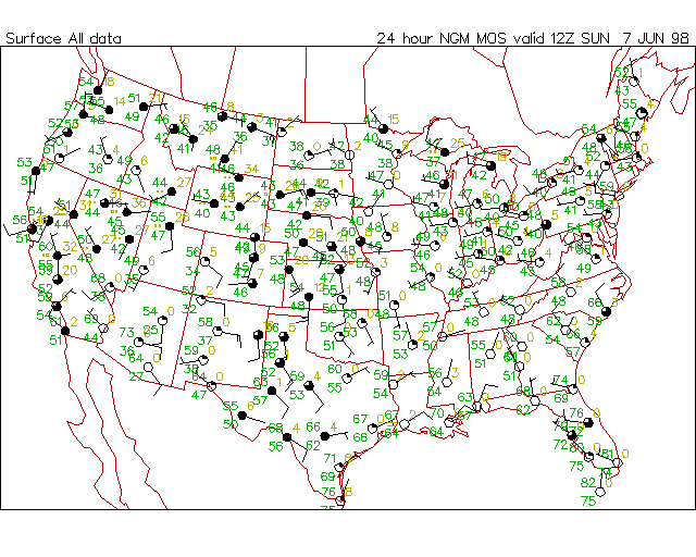
Model Output Statistics (MOS) data may be plotted with the fouswx program. This program works much like the surface plotting program except a forecast time menu replaces the region menu. MOS data cover many of the same stations that report surface data so data filtering (priority, grid filter) are applied based on the domain. The forecast time menu ranges from 6 to 60 hours for NGM surface MOS, 1 to 7 days for MRF MOS, initial to 48 hours for upper air MOS. Once the forecast time has been selected, the menu listing the available variables to be plotted is displayed. There are several varieties of composite data plots:
- NGM/LFM all data: This plots a cloud cover symbol with wind barb, forecasted temperature-upper left, forecasted dewpoint-lower left, predicted weather (symbol based on 6 hour forecast data)-left center, 6 hour probability of precipitation-upper right.
- NGM/LFM climate data: This plots a cloud cover symbol with wind barb, extreme temperature-upper left, predicted weather (symbol based on 12 hour forecast data)-left center, 12 hour probability of precipitation-upper right.
- LFM_UA/NGM_UA/ETA_UA all data: This pots a wind barb, lifted index-upper left, 1000-500 mb thickness (10m)-lower left, sea level pressure (last 3 digits)-upper right, 6 hour precipitation-lower right.
- MRF climate data: This plots maximum temperature-upper left, minimum temperature-lower left, departure from normal-upper right.
- MRFX climate data: This plots a cloud cover symbol, maximum temperature-upper left, minimum temperature-lower left, 24 probability of precipitation-upper right.

Present Weather Determination
The estimated type of weather on NGM plots is based on the following information:
- Precipitation based on probability of precipitation > 30%,
- Precipitation type based on PTYPE field (rain, snow, freezing rain),
- Precipitation intensity based on quantitative precipitation QPF field (see below),
- Existence of thunderstorms based on probability of thunderstorm > 20%,
- Existence of severe thunderstorms based on severe thunderstorm probability > 30%,
- Existence of obscuration (fog/haze) based on VIS field < 1 mile where obscuration type determined by OBVIS field.
Precipitation type and intensity based on 6 hour information
| Type | 1 | 2 | 3 | 4 | 5 |
|---|---|---|---|---|---|
| Rain | R- | R- | R- | R | R+ |
| Freezing | ZR- | ZR- | ZR | ZR+ | ZR+ |
| Snow | S- | S- | S | S+ | S+ |
Precipitation type and intensity based on 12 hour information
| Type | 1 | 2 | 3 | 4 | 5 | 6 |
|---|---|---|---|---|---|---|
| Rain | R- | R- | R- | R- | R | R+ |
| Freezing | ZR- | ZR- | ZR- | ZR | ZR+ | ZR+ |
| Snow | S- | S- | S- | S | S+ | S+ |
fouswx -cu -ft=h24 -va=all -de=d
MOS Gridding and Contouring
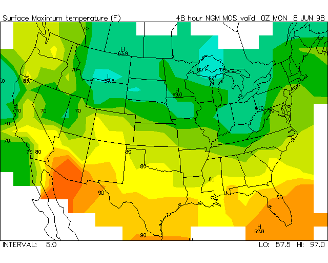
The MOS data gridding and contouring program is focalc. This program works similar to the surface gridding program and the MOS data plotting program. A forecast time is selected for gridding and the variables to be contoured represent the input data plus standard derived variables. Once a forecast time and variable have been selected, the gridding and contouring are performed and displayed. Wind vectors may also be plotted using U and V wind component grids as input.
focalc -cu=la -ft=d2 -va=maxt -ct=rainbow.clr -cof=0-23 -de=d -pl=cf -in=5 -cb=0
Last updated June 6, 1998

